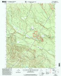
1998 Map of Pondosa
USGS Topo · Published 2003About this map
Pondosa serves as a focal point for this late-20th-century survey along the boundary of Siskiyou and Shasta counties. The landscape is defined by the high-elevation flats and ridges of the Shasta-Trinity National Forests, where drainage systems like North Fork Bear Creek and North Fork Clark Creek carve through the timberland. Evidence of land use and resource management is visible through features such as the Pondosa Dam, the remote Harlow Place, and several gravel pits. Notable named terrain includes Tom Young Flat, Whitlow Ridge, and Bosworth Meadow, illustrating the specific topographic identifiers used by the Forest Service and local residents. High-voltage powerlines and a Communication Facility underscore the infrastructure supporting this section of northern California.
Find a feature on this map
26 named features on this map. Tap any name to fly to it.
Don’t see what you’re looking for? This feature index may not catch every label — zoom into the map to look around manually.
Map Details
Editions of this 1998 Pondosa Map
This is the sole edition of this map. No revisions or reprints were ever made.
Other maps of this area

1886 · Modoc Lava Bed
USGS Topo · 1:250,000

1892 · Modoc Lava-Bed
USGS Topo · 1:250,000

1932 · Bartle
USGS Topo · 1:96,000

1939 · Bartle
USGS Topo · 1:125,000

1954 · Alturas
USGS Topo · 1:250,000

1958 · Alturas
USGS Topo · 1:250,000

1961 · Hambone
USGS Topo · 1:62,500

1961 · Pondosa
USGS Topo · 1:62,500
1961 · Big Bend
USGS Topo · 1:62,500

1961 · Bartle
USGS Topo · 1:62,500