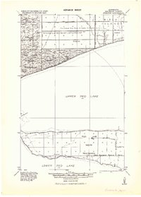
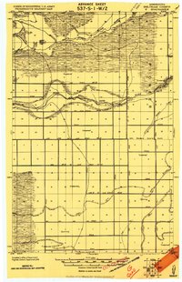
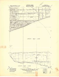
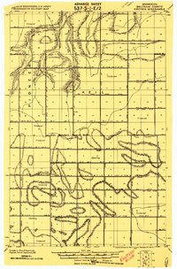
1943 Map of Ponemah
USGS Topo · Published 1943About this map
The Red Lake Indian Reservation is documented here during the early 1940s, based on earlier surveys by the Army Corps of Engineers and the Army Map Service. The map covers the land between Upper Red Lake and Lower Red Lake, specifically focusing on the settlement of Ponemah and the hydrologic alterations of the surrounding timbered lands. Detailed drainage work is evident through features like the Main Ditch, Jud. Ditch No. 25, and Jud. Ditch No. 82, which were part of early 20th-century efforts to reclaim swamp territory. To the north, Birch Island stands out near the village of Smithport, while the shoreline is marked by prominent landmarks such as Stony Point and the passage known as The Narrows. This document is particularly valuable for tracing the 1908 and 1913 drainage survey limits across the Ceded Chippewa Lands.
Find a feature on this map
20 named features on this map. Tap any name to fly to it.
Don’t see what you’re looking for? This feature index may not catch every label — zoom into the map to look around manually.
Map Details
Editions of this 1943 Ponemah Map
This is the sole edition of this map. No revisions or reprints were ever made.
Other maps of this area

1918 · F
USGS Topo · 1:62,500
1919 · G
USGS Topo · 1:62,500

1919 · Fox
USGS Topo · 1:62,500

1919 · Quiring
USGS Topo · 1:62,500
1919 · Ponemah
USGS Topo · 1:62,500
1919 · Knutson
USGS Topo · 1:62,500

1954 · Bemidji
USGS Topo · 1:250,000

1954 · Roseau
USGS Topo · 1:250,000

1957 · Roseau
USGS Topo · 1:250,000

1957 · Bemidji
USGS Topo · 1:250,000