1973 Map of Ponemah
USGS Topo · Published 1976About this map
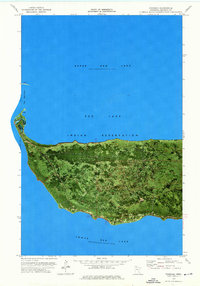
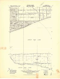
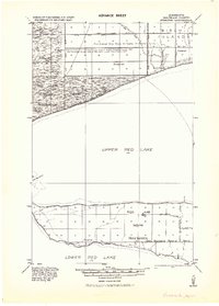
The Narrows separates the two massive basins of the Red Lake Indian Reservation in northern Minnesota, defining the geographic heart of the region. This 1973 orthophotomap provides a rare hybrid view of the landscape, combining traditional topographic data with aerial photography to reveal the dense forest cover and wetlands surrounding Ponemah. Situated on the peninsula between Upper Red Lake and Lower Red Lake, the community is anchored by local landmarks including a Radio Tower and several rural Cem sites. The imagery highlights the delicate transition between the water's edge and the inland marshes, marking the exact elevation of the normal reservoir pools at 1175 feet. This specific survey era captures the road network and settlement patterns within the reservation before further modern development altered the shoreline profile.
Find a feature on this map
12 named features on this map. Tap any name to fly to it.
Don’t see what you’re looking for? This feature index may not catch every label — zoom into the map to look around manually.
Map Details
Editions of this 1973 Ponemah Map
This is the sole edition of this map. No revisions or reprints were ever made.
Other maps of this area
1919 · Ponemah
USGS Topo · 1:62,500
1943 · Ponemah
USGS Topo · 1:62,500

1954 · Bemidji
USGS Topo · 1:250,000

1954 · Roseau
USGS Topo · 1:250,000

1957 · Roseau
USGS Topo · 1:250,000

1957 · Bemidji
USGS Topo · 1:250,000

1958 · Bemidji
USGS Topo · 1:250,000

1958 · Roseau
USGS Topo · 1:250,000

1972 · Redby NE
USGS Topo · 1:24,000

1973 · Manomin Creek SE
USGS Topo · 1:24,000