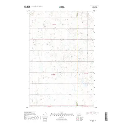
2018 Map of Pony Gulch
USGS Topo · Published 2018About this map
Pony Gulch sits in the northeast corner of this map, marking a subtle change in the prairie landscape where the North Dakota terrain begins to undulate with numerous small wetlands and potholes. The area is defined by a rigorous grid of section lines and gravel roads, including 14th St NE and 20th Ave NE, which carve the landscape into a pattern of agriculture and drainage. This survey documents the boundary between Sheridan and Wells Counties, a line that runs vertically through the eastern portion of the sheet. The density of seasonal water bodies shown here illustrates the glacial legacy of this region, where countless small depressions have become essential features of the local environment. Most of the map is occupied by the townships of t147n r74w and t148n r74w, showing a late 2010s view of a territory primarily shaped by rural section layouts and natural water catchments.
Find a feature on this map
23 named features on this map. Tap any name to fly to it.
Don’t see what you’re looking for? This feature index may not catch every label — zoom into the map to look around manually.
Map Details
Editions of this 2018 Pony Gulch Map
This is the sole edition of this map. No revisions or reprints were ever made.
Other maps of this area

1945 · Manfred
USGS Topo · 1:62,500

1946 · Sheyenne Lake
USGS Topo · 1:48,000

1947 · Sheyenne Lake
USGS Topo · 1:62,500

1948 · Manfred
USGS Topo · 1:62,500

1949 · Manfred SW
USGS Topo · 1:24,000

1950 · Manfred NW
USGS Topo · 1:24,000

1950 · Sheyenne Lake NE
USGS Topo · 1:24,000

1950 · Sheyenne Lake
USGS Topo · 1:24,000

1950 · Manfred SW
USGS Topo · 1:24,000

1952 · New Rockford
USGS Topo · 1:250,000