
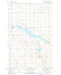
1950 Map of Sheyenne Lake
USGS Topo · Published 1950About this map
Sheyenne Lake and Coal Mine Lake dominate this central North Dakota landscape, situated along the upper reaches of the Sheyenne River. Surveyed as part of the Department of the Interior program for the development of the Missouri River Basin, the map reveals a rural community structured around local school districts and country churches. The distribution of Berlin Sch No 3, Berlin Sch No 4, and several New Germantown schools illustrates the township-based educational system of the mid-20th century. Cultural hubs are visible at St Johns Ch and Zion Ch, while the presence of Windmills and a Spillway near Lone Tree Lake points to the essential role of water management in this agricultural region. Genealogists may find particular value in identifying landmarks like the St Emanuel Cem located in the southern portion of the quadrangle.
Find a feature on this map
18 named features on this map. Tap any name to fly to it.
Don’t see what you’re looking for? This feature index may not catch every label — zoom into the map to look around manually.
Map Details
Editions of this 1950 Sheyenne Lake Map
2 editions found
Other maps of this area

1930 · Drake
USGS Topo · 1:62,500

1940 · Aylmer
USGS Topo · 1:62,500

1946 · Sheyenne Lake
USGS Topo · 1:48,000

1947 · Lincoln Valley
USGS Topo · 1:62,500

1947 · Sheyenne Lake
USGS Topo · 1:62,500

1950 · Sheyenne Lake NE
USGS Topo · 1:24,000

1951 · Martin
USGS Topo · 1:24,000

1951 · Anamoose SW
USGS Topo · 1:24,000

1954 · McClusky
USGS Topo · 1:250,000

1958 · McClusky
USGS Topo · 1:250,000