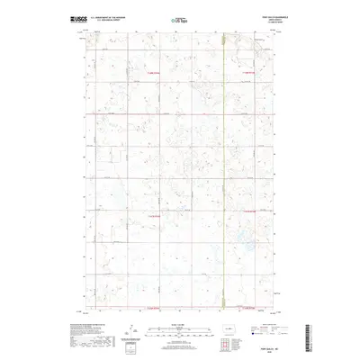
2020 Map of Pony Gulch
USGS Topo · Published 2020About this map
The border of Sheridan Co and Wells Co divides this North Dakota landscape, which is defined by a complex network of seasonal wetlands and prairie potholes. The land is organized by the Public Land Survey System, with townships like t147n r74w and t148n r73w providing a grid for local section roads. In the northeast corner, the namesake Pony Gulch appears as a distinct geographical feature amidst the high concentration of small water bodies. The transport network consists almost entirely of a numbered grid of local roads, such as 14th St NE and 6th St NE, which serve the agricultural parcels that dominate the region. This 2020 map reflects a modern view of the high plains, where the natural drainage of the wetlands remains the primary influence on the placement of rural infrastructure.
Find a feature on this map
16 named features on this map. Tap any name to fly to it.
Don’t see what you’re looking for? This feature index may not catch every label — zoom into the map to look around manually.
Map Details
Editions of this 2020 Pony Gulch Map
This is the sole edition of this map. No revisions or reprints were ever made.
Other maps of this area

1945 · Manfred
USGS Topo · 1:62,500

1946 · Sheyenne Lake
USGS Topo · 1:48,000

1947 · Sheyenne Lake
USGS Topo · 1:62,500

1948 · Manfred
USGS Topo · 1:62,500

1949 · Manfred SW
USGS Topo · 1:24,000

1950 · Manfred NW
USGS Topo · 1:24,000

1950 · Sheyenne Lake NE
USGS Topo · 1:24,000

1950 · Sheyenne Lake
USGS Topo · 1:24,000

1950 · Manfred SW
USGS Topo · 1:24,000

1952 · New Rockford
USGS Topo · 1:250,000