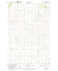
1978 Map of Pony Gulch
USGS Topo · Published 1979About this map
Glacial prairie potholes and scattered wetlands define this landscape in Sheridan and Wells Counties, where the Missouri Coteau's distinct topography is punctuated by Crystal Lake. The late 1970s terrain reveals a rural economy organized around civil townships like Boone, Fairview, Goodrich, and Bull Moose. A solitary Townhall stands centrally, reflecting the localized government structure of the era. Much of the northeast quadrant is dedicated to the National Waterfowl Production Area, highlighting the region's importance as a migratory bird habitat. The eponymous Pony Gulch cuts through the northern sections, while industrial activity is limited to a few resource extraction sites such as a Gravel Pit and Sandpit. This survey serves as a detailed record of the drainage patterns and township divisions before modern agricultural consolidation.
Find a feature on this map
11 named features on this map. Tap any name to fly to it.
Don’t see what you’re looking for? This feature index may not catch every label — zoom into the map to look around manually.
Map Details
Editions of this 1978 Pony Gulch Map
This is the sole edition of this map. No revisions or reprints were ever made.
Other maps of this area

1945 · Manfred
USGS Topo · 1:62,500

1946 · Sheyenne Lake
USGS Topo · 1:48,000

1947 · Sheyenne Lake
USGS Topo · 1:62,500

1948 · Manfred
USGS Topo · 1:62,500

1949 · Manfred SW
USGS Topo · 1:24,000

1950 · Manfred NW
USGS Topo · 1:24,000

1950 · Sheyenne Lake NE
USGS Topo · 1:24,000

1950 · Sheyenne Lake
USGS Topo · 1:24,000

1950 · Manfred SW
USGS Topo · 1:24,000

1952 · New Rockford
USGS Topo · 1:250,000