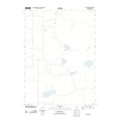
2011 Map of Pony Lake
USGS Topo · Published 2011About this map
Eureka Valley Cemetery stands as a quiet focal point in this portion of Rock County, where the landscape is defined by a dense network of natural basins and seasonal watercourses. The drainage patterns here are intricate, centered around the South Fork Elkhorn River and the recurring presence of Dry Creek. This Nebraska sandhills region is notable for its numerous named lakes, which likely served as critical landmarks and resources for local ranching operations. From the namesake Pony Lake in the south to Snipe Lake, Wolf Lake, and Goose Lake further north, these water bodies dictate the layout of the area's sparse road network. The map reveals a rural environment where land use is closely tied to these hydrologic features, with small clusters of development often situated near the shorelines of lakes like Otter Lake or Carlisle Lake.
Find a feature on this map
12 named features on this map. Tap any name to fly to it.
Don’t see what you’re looking for? This feature index may not catch every label — zoom into the map to look around manually.
Map Details
Editions of this 2011 Pony Lake Map
This is the sole edition of this map. No revisions or reprints were ever made.
Other maps of this area

1954 · Stuart
USGS Topo · 1:24,000

1954 · Newport
USGS Topo · 1:24,000

1954 · Newport SW
USGS Topo · 1:24,000

1955 · O'Neill
USGS Topo · 1:250,000

1959 · O'Neill
USGS Topo · 1:250,000

1969 · O'Neill
USGS Topo · 1:250,000
1982 · Linke Lake
USGS Topo · 1:24,000

1982 · Stockdale Lake
USGS Topo · 1:24,000

1982 · Sybrant
USGS Topo · 1:24,000

1982 · Dora Lake
USGS Topo · 1:24,000