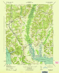
1943 Map of Popes Creek
USGS Topo · Published 1943About this map
The Pennsylvania (Popes Creek Br) railroad defines the western corridor of this Southern Maryland landscape, connecting the inland junction at Bel Alton to the river terminal at Popes Creek. This 1943 survey, compiled by the U. S. Coast and Geodetic Survey from aerial photographs, reveals a coastal economy transitioning from agricultural landings to mid-century rural infrastructure. Centered on the sprawling Zekiah Swamp, the map documents established settlements like Newport and Allens Fresh alongside small family landmarks such as Rogers Mill and St Marys Ch. The topography shows a highly dissected terrain where numerous creeks, including Gilbert Swamp Run and Cooksey Run, drain into the Wicomico River. Strategic crossings like Stones Bridge and Dentsville Bridge serve as local hubs for the surrounding districts, including Allens Fresh No 4 and Harris Lot No 5.
Find a feature on this map
78 named features on this map. Tap any name to fly to it.
Don’t see what you’re looking for? This feature index may not catch every label — zoom into the map to look around manually.
Map Details
Editions of this 1943 Popes Creek Map
This is the sole edition of this map. No revisions or reprints were ever made.
Other maps of this area

1889 · Fredericksburg
USGS Topo · 1:125,000

1890 · Mt. Vernon
USGS Topo · 1:125,000

1891 · Mt. Vernon
USGS Topo · 1:125,000

1892 · Fredericksburg
USGS Topo · 1:125,000

1892 · Brandywine
USGS Topo · 1:62,500

1894 · Wicomico
USGS Topo · 1:62,500

1894 · Fredericksburg
USGS Topo · 1:125,000

1894 · Mt. Vernon
USGS Topo · 1:125,000

1895 · Wicomico
USGS Topo · 1:62,500

1895 · Brandywine
USGS Topo · 1:62,500