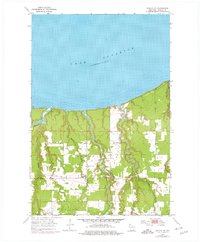
1954 Map of Poplar NE
USGS Topo · Published 1976About this map
Lake Superior dominates the northern horizon of this Douglas County coastal landscape, where the shoreline meets a complex network of north-flowing waterways. Small rural centers like Lakeside anchor the interior, served by the local Lakeside Sch and the Lakeside Cem. The terrain is defined by the deep incisions of the Amnicon River, Middle River, and Poplar River, which drain the township toward the Great Lake.
Find a feature on this map
16 named features on this map. Tap any name to fly to it.
Don’t see what you’re looking for? This feature index may not catch every label — zoom into the map to look around manually.
Map Details
Editions of this 1954 Poplar NE Map
2 editions found
Other maps of this area

1947 · Brule
USGS Topo · 1:48,000

1949 · Poplar
USGS Topo · 1:48,000

1953 · Lakewood
USGS Topo · 1:24,000

1953 · Ashland
USGS Topo · 1:250,000

1954 · Lake Nebagamon
USGS Topo · 1:24,000

1954 · Poplar NE
USGS Topo · 1:24,000
1954 · South Range
USGS Topo · 1:24,000

1954 · Poplar
USGS Topo · 1:24,000

1954 · Cloverland
USGS Topo · 1:24,000
1954 · Parkland
USGS Topo · 1:24,000