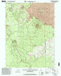
1998 Map of Porcupine Butte
USGS Topo · Published 2003About this map
The Burnt Lava Flow Geological Area dominates the northern expanse of this Siskiyou County landscape, revealing a complex volcanic terrain defined by stark geologic transitions. Volcanic activity is etched into the topography through features like Deep Crater, Double Hole Crater, and Porcupine Butte. The map details the intersection of the Shasta Trinity National Forest and Modoc National Forest, where resource management is marked by a Cinder Pit and a network of Forest Service routes including the Mc Cloud Big Valley Rd. In the southern reaches, the small settlement of Lakin sits near the base of these volcanic highlands, while Porcupine Lake provides a rare water feature amidst the cinder hills and lava flows. This survey captures a specialized mountain environment shaped by post-glacial volcanism and mid-century forestry.
Find a feature on this map
20 named features on this map. Tap any name to fly to it.
Don’t see what you’re looking for? This feature index may not catch every label — zoom into the map to look around manually.
Map Details
Editions of this 1998 Porcupine Butte Map
This is the sole edition of this map. No revisions or reprints were ever made.
Other maps of this area

1886 · Modoc Lava Bed
USGS Topo · 1:250,000

1892 · Modoc Lava-Bed
USGS Topo · 1:250,000

1932 · Bartle
USGS Topo · 1:96,000

1939 · Bartle
USGS Topo · 1:125,000

1952 · Timber Mountain
USGS Topo · 1:62,500

1952 · Medicine Lake
USGS Topo · 1:62,500

1954 · Alturas
USGS Topo · 1:250,000

1958 · Alturas
USGS Topo · 1:250,000

1961 · Hambone
USGS Topo · 1:62,500

1962 · Alturas
USGS Topo · 1:250,000