1983 Map of Port Arthur
USGS Topo · Published 1983About this map
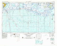
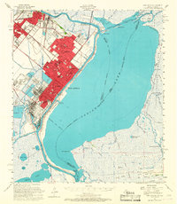
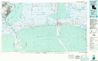
Port Arthur and Port Neches dominate the northwestern corner of this topographic-bathymetric study, positioned at the edge of the Neches River and the industrial waterway systems of the Texas-Louisiana border. The coastal landscape is defined by the expansive Sabine National Wildlife Refuge and a series of unique geological ridges, such as Pines Ridge and Blue Buck Ridge, which provided elevated ground for early settlements and travel in an otherwise marsh-heavy environment. This map highlights the complex relationship between the natural wetlands and the region’s industrial development, specifically the West Hackberry Oil Field and the Intracoastal Waterway. To the south, the bathymetry of the Gulf of Mexico is mapped alongside offshore lease areas like the 7 High Island Area 8 Sabine Pass Area, while the shoreline features small fishing and coastal communities like Holly Beach and Johnson Bayou Landing.
Find a feature on this map
70 named features on this map. Tap any name to fly to it.
Don’t see what you’re looking for? This feature index may not catch every label — zoom into the map to look around manually.
Map Details
Editions of this 1983 Port Arthur Map
This is the sole edition of this map. No revisions or reprints were ever made.
Historical Maps of Port Arthur Through Time
7 maps found