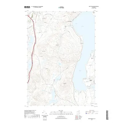
2019 Map of Port Douglass
USGS Topo · Published 2019About this map
The shores of Lake Champlain define the eastern edge of this landscape, where the rugged topography of the Adirondack Park meets the water at Port Douglass and Willsboro Point. The interior is characterized by a series of significant peaks, including Trembleau Mtn, Drake Mtn, and Rattlesnake Mtn, which rise above numerous isolated water bodies such as Highlands Forge Lake, Augur Lake, and Long Pond. This area on the border of Clinton and Essex counties shows a complex network of glacial ponds and small drainage systems like Little Trout Brook and Shanty Brook. A mix of recreation and local history is evident, with the small Port Douglass Cem and various points of interest like Buttermilk Falls situated among the winding mountain roads. The map illustrates the contrast between the developed peninsulas and the dense forest lands of the Adirondack interior.
Find a feature on this map
65 named features on this map. Tap any name to fly to it.
Don’t see what you’re looking for? This feature index may not catch every label — zoom into the map to look around manually.
Map Details
Editions of this 2019 Port Douglass Map
This is the sole edition of this map. No revisions or reprints were ever made.
Other maps of this area

1894 · Plattsburg
USGS Topo · 1:62,500

1895 · Willsboro
USGS Topo · 1:62,500

1895 · Ausable
USGS Topo · 1:62,500

1903 · Ausable
USGS Topo · 1:62,500

1906 · Plattsburg
USGS Topo · 1:62,500

1913 · Dannemora
USGS Topo · 1:62,500

1939 · Plattsburg
USGS Topo · 1:62,500

1941 · Plattsburg
USGS Topo · 1:62,500

1941 · Willsboro
USGS Topo · 1:62,500

1943 · Willsboro
USGS Topo · 1:62,500