
1939 Map of Plattsburg
USGS Topo · Published 1939About this map
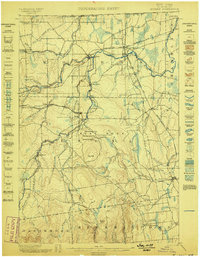
The Plattsburg Barracks and the adjoining Plattsburg Training Camp dominate the shoreline of Lake Champlain in this pre-war survey. The map details the strategic and recreational importance of the waterfront, from the Municipal Beach to the sprawling grounds of the Hotel Champlain at Bluff Pt. Transportation networks are well-defined, showing the Rutland Railroad traversing Grand Isle and the Delaware and Hudson line serving the mainland. To the south, the dramatic geology of the Ausable River is preserved within Ausable Chasm State Park near Keeseville. On the Vermont side, the rural character of South Hero is dotted with local institutions like the Pearl Sch and Westerly Chapel. The inclusion of the Sand Bar Bridge and several ferry routes illustrates the vital connections between the lake islands and the New York coast.
Find a feature on this map
116 named features on this map. Tap any name to fly to it.
Don’t see what you’re looking for? This feature index may not catch every label — zoom into the map to look around manually.
Map Details
Editions of this 1939 Plattsburg Map
This is the sole edition of this map. No revisions or reprints were ever made.
Other maps of this area

1894 · Plattsburg
USGS Topo · 1:62,500

1895 · Mooers
USGS Topo · 1:62,500

1895 · Rouse Point
USGS Topo · 1:62,500

1895 · Willsboro
USGS Topo · 1:62,500

1895 · Ausable
USGS Topo · 1:62,500
1899 · Mooers
USGS Topo · 1:62,500

1903 · Ausable
USGS Topo · 1:62,500

1906 · Plattsburg
USGS Topo · 1:62,500

1906 · Burlington
USGS Topo · 1:62,500

1907 · Rouse Point
USGS Topo · 1:62,500