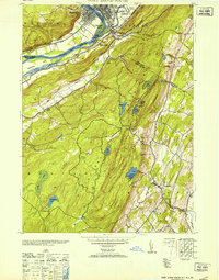
1953 Map of Port Jervis South
USGS Topo · Published 1953About this map
Tristates serves as a critical junction where New York, New Jersey, and Pennsylvania converge at the confluence of the Delaware River and Neversink River. This mid-century survey illustrates the complex geography of the Tri-State area, dominated by the ridge of High Point State Park and its landmark High Point monument. The settlement patterns reflect a landscape defined by water and topography, with the Erie RR following the river valleys and small hamlets like Colesville and Duttonville scattered along the lower elevations. Higher elevations remain largely undeveloped, characterized by numerous water bodies such as Lake Marcia and Steeny Kill Lake. The presence of the Matamoras Airport and the Life Magazine Camp indicates the region's mid-century role as both a transportation hub and a destination for recreation and institutional camps, while localized industry is represented by the Rock Quarry near Clove Brook.
Find a feature on this map
43 named features on this map. Tap any name to fly to it.
Don’t see what you’re looking for? This feature index may not catch every label — zoom into the map to look around manually.
Map Details
Editions of this 1953 Port Jervis South Map
This is the sole edition of this map. No revisions or reprints were ever made.
Other maps of this area

1888 · Franklin
USGS Topo · 1:62,500

1891 · Wallpack
USGS Topo · 1:62,500

1893 · Wallpack
USGS Topo · 1:62,500

1894 · Franklin
USGS Topo · 1:62,500

1897 · Franklin
USGS Topo · 1:62,500

1903 · Franklin Furnace
USGS Topo · 1:62,500

1906 · Port Jervis
USGS Topo · 1:62,500

1908 · Port Jervis
USGS Topo · 1:62,500

1913 · Milford
USGS Topo · 1:62,500

1915 · Milford
USGS Topo · 1:62,500