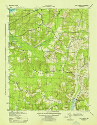
1944 Map of Port Tobacco
USGS Topo · Published 1944About this map
Mattawoman Creek and its tributary valleys define the terrain of central Charles County during the mid-1940s. The landscape is characterized by a network of small drainage runs like Old Womans Run and Jennie Run, which flow through a countryside dotted with established rural centers. The U S Government Railroad cuts a diagonal path across the northern reaches, serving as a significant military-industrial corridor through this largely agricultural area.
Find a feature on this map
18 named features on this map. Tap any name to fly to it.
Don’t see what you’re looking for? This feature index may not catch every label — zoom into the map to look around manually.
Map Details
Editions of this 1944 Port Tobacco Map
This is the sole edition of this map. No revisions or reprints were ever made.
Other maps of this area

1889 · Fredericksburg
USGS Topo · 1:125,000

1890 · Mt. Vernon
USGS Topo · 1:125,000

1891 · Mt. Vernon
USGS Topo · 1:125,000

1892 · Fredericksburg
USGS Topo · 1:125,000

1892 · Brandywine
USGS Topo · 1:62,500

1894 · Wicomico
USGS Topo · 1:62,500

1894 · Fredericksburg
USGS Topo · 1:125,000

1894 · Mt. Vernon
USGS Topo · 1:125,000

1895 · Wicomico
USGS Topo · 1:62,500

1895 · Brandywine
USGS Topo · 1:62,500