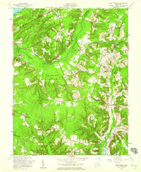
1956 Map of Port Tobacco
USGS Topo · Published 1959About this map
The Port Tobacco area of Charles County is defined by a dense network of tidal creeks and historically significant estates as it appeared in the mid-1950s. The landscape is anchored by the Thomas Stone Nat Hist Site and the historic Haber de Venture estate, reflecting the region's deep colonial and post-revolutionary roots. To the north, the Government Railroad cuts through the terrain, serving military and logistical needs with sidings like Pomfret Siding and Rassmussens Siding. Small rural hubs such as Pomonkey, Pomfret, and Bennsville are depicted with their local institutions, including the Pomonkey Sch and St Joseph Ch. Along the western edge, the terrain slopes toward the Potomac River at Chapman Landing, while the central portion is dominated by the sprawling Myrtle Grove Game Farm. The map also highlights the transition toward modern infrastructure with the Maryland Airport and the Indian Head Highway.
Find a feature on this map
47 named features on this map. Tap any name to fly to it.
Don’t see what you’re looking for? This feature index may not catch every label — zoom into the map to look around manually.
Map Details
Editions of this 1956 Port Tobacco Map
This is the sole edition of this map. No revisions or reprints were ever made.
Other maps of this area

1889 · Fredericksburg
USGS Topo · 1:125,000

1890 · Mt. Vernon
USGS Topo · 1:125,000

1891 · Mt. Vernon
USGS Topo · 1:125,000

1892 · Fredericksburg
USGS Topo · 1:125,000

1892 · Brandywine
USGS Topo · 1:62,500

1894 · Wicomico
USGS Topo · 1:62,500

1894 · Fredericksburg
USGS Topo · 1:125,000

1894 · Mt. Vernon
USGS Topo · 1:125,000

1895 · Wicomico
USGS Topo · 1:62,500

1895 · Brandywine
USGS Topo · 1:62,500