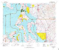
1975 Map of Port Townsend
USGS Topo · Published 1977About this map
The complex marine geography of the northern Puget Sound is revealed in this 1970s survey, dominated by the long forms of Whidbey Island and Camano Island. The landscape reflects a high concentration of strategic military and maritime infrastructure, from the expansive Whidbey Island Naval Air Station to coastal fortifications like Fort Worden Military Res and Fort Flagler Military Res. These sites, alongside the Lake Hancock Target Range, indicate the area's significance in Pacific Northwest defense.
Find a feature on this map
267 named features on this map. Tap any name to fly to it.
Don’t see what you’re looking for? This feature index may not catch every label — zoom into the map to look around manually.
Map Details
Editions of this 1975 Port Townsend Map
This is the sole edition of this map. No revisions or reprints were ever made.
Other maps of this area

1895 · Snohomish
USGS Topo · 1:125,000

1897 · Seattle
USGS Topo · 1:125,000

1899 · Stillaguamish
USGS Topo · 1:125,000

1901 · Stilaguamish
USGS Topo · 1:125,000

1909 · Mt Baker
USGS Topo · 1:192,000

1911 · Mount Vernon
USGS Topo · 1:125,000

1915 · Mt. Baker
USGS Topo · 1:250,000

1918 · Samish Lake
USGS Topo · 1:62,500

1921 · Wickersham
USGS Topo · 1:62,500

1921 · Sultan
USGS Topo · 1:125,000