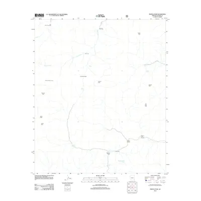
2012 Map of Portal Peak
USGS Topo · Published 2012About this map
The Monte Vista Peak Lookout stands watch over this high-desert and mountain landscape in the Chiricahua range during the early 21st century. The map details a network of canyons and peaks, including Pot Hole Peak, Darnell Peak, and Portal Peak, which define the local topography. Human presence is marked by established forest sites like South Fork Forest Camp and Herb Martyr Forest Camp, alongside the private Roush Ranch in the southern reaches. Water sources, vital in this environment, are mapped as a series of springs and tanks such as Dripping Spring, Burro Spring, and Horseshoe Tank Number Three. The drainage patterns of Cave Cr and its tributaries, including S Fork Cave Cr, illustrate the seasonal flow through Pothole Canyon and North Fork Canyon, while S Fork Rd and Sulphur Rd provide the primary access through the steep terrain.
Find a feature on this map
27 named features on this map. Tap any name to fly to it.
Don’t see what you’re looking for? This feature index may not catch every label — zoom into the map to look around manually.
Map Details
Editions of this 2012 Portal Peak Map
This is the sole edition of this map. No revisions or reprints were ever made.
Other maps of this area

1917 · Chiricahua
USGS Topo · 1:125,000

1919 · Chiricahua
USGS Topo · 1:125,000

1926 · Rodeo
USGS Topo · 1:62,500

1926 · Rucker
USGS Topo · 1:62,500

1926 · Pedregosa
USGS Topo · 1:62,500

1940 · Apache
USGS Topo · 1:62,500

1955 · Douglas
USGS Topo · 1:250,000

1958 · Chiricahua Peak
USGS Topo · 1:62,500

1958 · Apache
USGS Topo · 1:62,500
1958 · Pedregosa Mountains
USGS Topo · 1:62,500