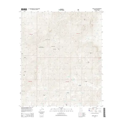
2014 Map of Portal Peak
USGS Topo · Published 2014About this map
Coronado National Forest defines the high-altitude landscape of this 2014 survey, dominated by the northern reaches of the Chiricahua Mountains. Rising significantly over the surrounding desert floor, Portal Peak and Sulphur Peak serve as primary landmarks for navigating this complex system of canyons and ridges. The topography is marked by a series of high-altitude gaps such as Horseshoe Pass and Jack Wood Pass, which historically facilitated movement through the range. A notable pattern of water management is evident through the numerous named tanks scattered across the map, including Horseshoe Tank Number One and Pot Hole Tank. These features, along with names like Sulphur Draw and Blevins Draw, highlight the essential role of water catchment in this arid environment, providing vital resources for both livestock and wildlife in the backcountry.
Find a feature on this map
43 named features on this map. Tap any name to fly to it.
Don’t see what you’re looking for? This feature index may not catch every label — zoom into the map to look around manually.
Map Details
Editions of this 2014 Portal Peak Map
This is the sole edition of this map. No revisions or reprints were ever made.
Other maps of this area

1917 · Chiricahua
USGS Topo · 1:125,000

1919 · Chiricahua
USGS Topo · 1:125,000

1926 · Rodeo
USGS Topo · 1:62,500

1926 · Rucker
USGS Topo · 1:62,500

1926 · Pedregosa
USGS Topo · 1:62,500

1940 · Apache
USGS Topo · 1:62,500

1955 · Douglas
USGS Topo · 1:250,000

1958 · Chiricahua Peak
USGS Topo · 1:62,500

1958 · Apache
USGS Topo · 1:62,500
1958 · Pedregosa Mountains
USGS Topo · 1:62,500