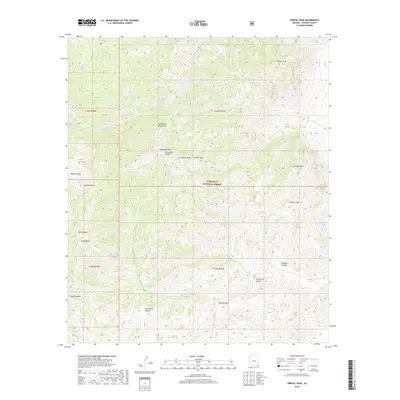
2018 Map of Portal Peak
USGS Topo · Published 2018About this map
The Chiricahua Mountains dominate this 2018 survey within the Coronado National Forest, illustrating a landscape defined by high summits and complex drainage systems in Cochise County. High points such as Portal Peak, Sentinel Peak, and Jones Peak anchor the terrain, while travelers would navigate via Horseshoe Pass and deep cuts like Baker Canyon or Jack Wood Canyon. The scarcity of surface water is evident in the naming of critical watering points, including Licklog Tank, Log Spring, and Kambitsch Tank. This modern USGS map maintains the traditional township and range survey lines, such as t18s r31e, providing a clear spatial framework for the canyons and draws that define this section of the Arizona borderlands.
Find a feature on this map
31 named features on this map. Tap any name to fly to it.
Don’t see what you’re looking for? This feature index may not catch every label — zoom into the map to look around manually.
Map Details
Editions of this 2018 Portal Peak Map
This is the sole edition of this map. No revisions or reprints were ever made.
Other maps of this area

1917 · Chiricahua
USGS Topo · 1:125,000

1919 · Chiricahua
USGS Topo · 1:125,000

1926 · Rodeo
USGS Topo · 1:62,500

1926 · Rucker
USGS Topo · 1:62,500

1926 · Pedregosa
USGS Topo · 1:62,500

1940 · Apache
USGS Topo · 1:62,500

1955 · Douglas
USGS Topo · 1:250,000

1958 · Chiricahua Peak
USGS Topo · 1:62,500

1958 · Apache
USGS Topo · 1:62,500
1958 · Pedregosa Mountains
USGS Topo · 1:62,500