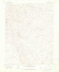
1961 Map of Porter Mountain
USGS Topo · Published 1972About this map
Grand Mesa National Forest and Gunnison National Forest meet at this high-altitude landscape along the border of Mesa and Delta counties. The 1961 field check records a network of water management features and seasonal grazing lands, centered on the high relief of Porter Mountain. Vital water resources are tracked through the McKelvie Reservoir and the Castle Ditch irrigation system, which cuts across the northern slopes near Lowell Flat. The mapping of several Jeep Trails and a Wagon Trail descending into Dead Mare Park illustrates the mid-century transition from traditional livestock grazing to recreational forest use. Prominent topographic landmarks such as Bronco Knob and the Flat Tops define the open, high-country character of the region, while drainage systems like Buzzard Creek and Plateau Creek provide the primary geographic structure for this corner of the Western Slope.
Find a feature on this map
36 named features on this map. Tap any name to fly to it.
Don’t see what you’re looking for? This feature index may not catch every label — zoom into the map to look around manually.
Map Details
Editions of this 1961 Porter Mountain Map
4 editions found
Other maps of this area

1955 · The Meadows
USGS Topo · 1:24,000

1957 · Leadville
USGS Topo · 1:250,000

1959 · Leadville
USGS Topo · 1:250,000

1960 · Leadville
USGS Topo · 1:250,000

1960 · Leon Peak
USGS Topo · 1:24,000

1960 · South Mamm Peak
USGS Topo · 1:24,000

1961 · Electric Mountain
USGS Topo · 1:24,000

1961 · Porter Mountain
USGS Topo · 1:24,000

1961 · Chalk Mountain
USGS Topo · 1:24,000

1961 · Spruce Mountain
USGS Topo · 1:24,000