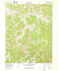
1979 Map of Portersburg
USGS Topo · Published 1979About this map
Portersburg and Fogertown anchor this 1970s topographical study of the dissected plateau where Laurel and Clay Counties meet. The landscape is defined by the winding course of the South Fork Rockcastle River and the high ridge of Cutoff Mountain, which separate small agricultural valleys from intensive extraction zones. The map documents an economy in transition, where traditional nodes like Benge and McWhorter coexist with extensive strip mines and scattered oil and gas wells. Local genealogy and community life are well-represented through numerous rural congregations and burial sites, including Wyatt Chapel, New Bethel Church, and the Linck Cemetery. The newly established Daniel Boone Parkway cuts through the southern hills, marking a significant change in regional accessibility near the settlement of Urban.
Find a feature on this map
51 named features on this map. Tap any name to fly to it.
Don’t see what you’re looking for? This feature index may not catch every label — zoom into the map to look around manually.
Map Details
Editions of this 1979 Portersburg Map
This is the sole edition of this map. No revisions or reprints were ever made.
Other maps of this area

1891 · Manchester
USGS Topo · 1:125,000

1893 · London
USGS Topo · 1:125,000

1897 · London
USGS Topo · 1:125,000

1952 · Portersburg
USGS Topo · 1:24,000

1952 · Hima
USGS Topo · 1:24,000

1952 · Blackwater
USGS Topo · 1:24,000

1952 · Lily
USGS Topo · 1:24,000

1952 · Manchester
USGS Topo · 1:24,000

1952 · London
USGS Topo · 1:24,000

1953 · Tyner
USGS Topo · 1:24,000