
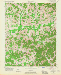
1952 Map of Blackwater
USGS Topo · Published 1953About this map
The historical Wilderness Road traverses this Laurel County landscape, cutting through the dense network of ridges and creek valleys south of Lida. In the early 1950s, this area of Kentucky maintained a traditional rural character defined by a high density of community centers, including Bush Ch and Providence Ch. Education was locally oriented with numerous small schools such as Camp Ground Sch, Merrimac Sch, and Fletcher Sch serving the scattered population. The map captures the transition from old overland routes to a post-war economy, evidenced by the presence of a Strip Mine and the established settlement at Blackwater. Numerous family cemeteries, such as the Jones Cem and McFadden Cem, are documented across the hills, providing valuable data for genealogical research into the families living along the Laurel River and Blackwater Creek.
Find a feature on this map
66 named features on this map. Tap any name to fly to it.
Don’t see what you’re looking for? This feature index may not catch every label — zoom into the map to look around manually.
Map Details
Editions of this 1952 Blackwater Map
2 editions found
Other maps of this area

1886 · Cumberland Gap
USGS Topo · 1:125,000

1888 · Cumberland Gap
USGS Topo · 1:125,000

1890 · Williamsburg
USGS Topo · 1:125,000

1891 · Manchester
USGS Topo · 1:125,000

1891 · Cumberland Gap
USGS Topo · 1:125,000

1893 · London
USGS Topo · 1:125,000

1894 · Williamsburg
USGS Topo · 1:125,000

1897 · London
USGS Topo · 1:125,000

1952 · Portersburg
USGS Topo · 1:24,000

1952 · Corbin
USGS Topo · 1:24,000