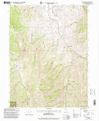
1998 Map of Porterville
USGS Topo · Published 2000About this map
Porterville sits at the confluence of several mountain drainages, serving as a primary settlement point in this corner of the Wasatch National Forest. The landscape is defined by the winding course of East Canyon Creek and its many tributaries, such as Hardscrabble Creek and Beaver Creek. Human infrastructure is closely tied to these water sources, evidenced by the Richville Diversion Dam and a Gaging Station located near The Narrows. Local history and family ties are anchored at the Porterville Cem, while the historic Salt Lake Rd suggests early transportation routes through the steep terrain. Names like Joe Durrant Hollow and Tom Adams Hollow reflect the legacy of early settlers who carved out lives in the canyons of Mahogany Ridge and East Canyon.
Find a feature on this map
41 named features on this map. Tap any name to fly to it.
Don’t see what you’re looking for? This feature index may not catch every label — zoom into the map to look around manually.
Map Details
Editions of this 1998 Porterville Map
This is the sole edition of this map. No revisions or reprints were ever made.
Other maps of this area

1885 · Salt Lake
USGS Topo · 1:250,000

1925 · Ft. Douglas
USGS Topo · 1:125,000

1928 · Ft. Douglas
USGS Topo · 1:125,000

1950 · Fort Douglas
USGS Topo · 1:24,000

1951 · Fort Douglas
USGS Topo · 1:24,000

1952 · Bountiful Peak
USGS Topo · 1:24,000

1954 · Salt Lake City
USGS Topo · 1:250,000

1954 · Ogden
USGS Topo · 1:250,000

1955 · Peterson
USGS Topo · 1:24,000

1958 · Ogden
USGS Topo · 1:250,000