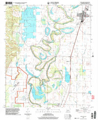
2002 Map of Portland
USGS Topo · Published 2004About this map
Bartholomew Bayou meanders through this portion of Ashley County, defining a landscape shaped by oxbow lakes and winding waterways like Wilson Brake and St Marion Brake. The settlement of Portland sits in the northeast corner, a hub of local activity marked by the Tillis High Sch and a local Water Tank. The mapping reflects a rural agricultural economy where small communities such as Sunshine and Parkdale are connected by roads that navigate around the complex hydrology of the delta.
Find a feature on this map
20 named features on this map. Tap any name to fly to it.
Don’t see what you’re looking for? This feature index may not catch every label — zoom into the map to look around manually.
Map Details
Editions of this 2002 Portland Map
This is the sole edition of this map. No revisions or reprints were ever made.
Other maps of this area

1935 · Mist
USGS Topo · 1:62,500

1935 · Wilmot
USGS Topo · 1:62,500

1936 · Eudora
USGS Topo · 1:62,500

1936 · Lake Village
USGS Topo · 1:62,500

1953 · Greenwood
USGS Topo · 1:250,000

1955 · Lake Village
USGS Topo · 1:62,500

1956 · Greenwood
USGS Topo · 1:250,000

1957 · Eudora
USGS Topo · 1:62,500

1960 · Snyder
USGS Topo · 1:24,000

1960 · Mist
USGS Topo · 1:62,500