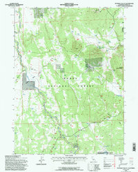
1993 Map of Pothole Valley
USGS Topo · Published 1996About this map
Pothole Valley defines this portion of the Modoc National Forest, where high-elevation drainage patterns and livestock management infrastructure characterize the landscape of the 1990s. The map reveals a network of water resources essential for this environment, including Pothole Spring, Quaking Aspen Spring, and the Timbered Ridge Reservoir. A notable human-made feature is the extensive Rock Wall following the contour of the valley near Boles Creek, likely a remnant of early ranching or boundary marking. This territory, punctuated by peaks like Blue Mountain and the long expanse of Bird Spring Ridge, shows very little permanent settlement outside of specialized sites such as a lonely Grave located near the center of the quadrangle. The presence of numerous Stock Ponds and the namesake Boles Meadow underscores the area's continued use for grazing and seasonal land management.
Find a feature on this map
21 named features on this map. Tap any name to fly to it.
Don’t see what you’re looking for? This feature index may not catch every label — zoom into the map to look around manually.
Map Details
Editions of this 1993 Pothole Valley Map
This is the sole edition of this map. No revisions or reprints were ever made.
Other maps of this area

1886 · Alturas
USGS Topo · 1:250,000

1886 · Modoc Lava Bed
USGS Topo · 1:250,000

1892 · Modoc Lava-Bed
USGS Topo · 1:250,000

1892 · Alturas
USGS Topo · 1:250,000

1951 · Clear Lake Reservoir
USGS Topo · 1:62,500

1952 · Hackamore
USGS Topo · 1:62,500

1954 · Alturas
USGS Topo · 1:250,000

1958 · Alturas
USGS Topo · 1:250,000

1962 · Alturas
USGS Topo · 1:250,000

1962 · Steele Swamp
USGS Topo · 1:62,500