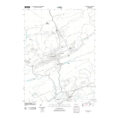
2010 Map of Pottsville
USGS Topo · Published 2010About this map
Pottsville serves as the focal point of this 21st-century landscape, where the Schuylkill River and its various branches carve through the anthracite coal region. The settlement pattern follows the valley floors, with dense neighborhoods in Saint Clair and Port Carbon tightly constrained by the surrounding ridges like Sharp Mountain. This modern survey reveals how the infrastructure of the industrial era has been repurposed, showing several water management sites including the Silver Creek Reservoir and Indian Run Reservoir, alongside newer developments like Chim Commercial Airport. To the south, the junctions at Cressona and Schuylkill Haven illustrate the historical importance of the river corridors for regional transit. Notable specific locales like York Farm Junction and Palo Alto highlight the intricate network of smaller communities that define this part of Schuylkill County.
Find a feature on this map
79 named features on this map. Tap any name to fly to it.
Don’t see what you’re looking for? This feature index may not catch every label — zoom into the map to look around manually.
Map Details
Editions of this 2010 Pottsville Map
This is the sole edition of this map. No revisions or reprints were ever made.
Other maps of this area

1889 · Catawissa
USGS Topo · 1:62,500

1889 · Pottsville
USGS Topo · 1:62,500

1891 · Pottsville
USGS Topo · 1:62,500

1892 · Catawissa
USGS Topo · 1:62,500

1892 · Mahanoy
USGS Topo · 1:62,500

1892 · Pine Grove
USGS Topo · 1:62,500

1893 · Mahanoy
USGS Topo · 1:62,500

1894 · Catawissa
USGS Topo · 1:62,500

1944 · Pottsville
USGS Topo · 1:24,000

1944 · Orwigsburg
USGS Topo · 1:24,000