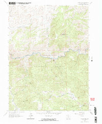
1962 Map of Poudre Park
USGS Topo · Published 1969About this map
The Cache La Poudre River cuts a sharp east-west path through the center of this terrain, serving as the primary corridor for movement and settlement within the Roosevelt National Forest. Small mountain outposts like Mishawaka and Poudre Park sit right along the riverbanks, where the valley floor provides enough level ground for buildings. This 1962 field-checked data shows a landscape transitioning between early twentieth-century resource extraction and growing recreational use. The presence of the Brinkhoff Mine Trail and the Stratton Park Sch point to a history of permanent mountain living and industry, while the Ansel Watrous Campground and systems like the Greyrock Trail near Greyrock Mountain suggest the area's shifting role toward forestry and leisure. Numerous gulches, including Hewlett Gulch and Young Gulch, drain the high ridges of Mount Ethel into the main river canyon.
Find a feature on this map
28 named features on this map. Tap any name to fly to it.
Don’t see what you’re looking for? This feature index may not catch every label — zoom into the map to look around manually.
Map Details
Editions of this 1962 Poudre Park Map
2 editions found
Other maps of this area

1906 · Fort Collins
USGS Topo · 1:62,500

1907 · Livermore
USGS Topo · 1:125,000

1908 · Fort Collins
USGS Topo · 1:62,500

1909 · Livermore
USGS Topo · 1:125,000

1954 · Greeley
USGS Topo · 1:250,000

1957 · Greeley
USGS Topo · 1:250,000

1958 · Greeley
USGS Topo · 1:250,000

1960 · Livermore
USGS Topo · 1:24,000

1960 · Haystack Gulch
USGS Topo · 1:24,000

1960 · Livermore Mountain
USGS Topo · 1:24,000