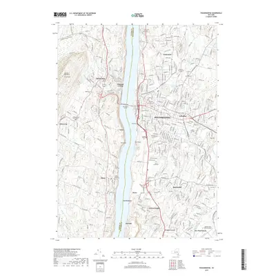
2019 Map of Poughkeepsie
USGS Topo · Published 2019About this map
The Hudson River serves as the primary artery of this mid-valley landscape, dividing the urban center of Poughkeepsie in Dutchess County from the orchard-laden slopes of Highland in Ulster County. The riverfront is a study in diverse land use, featuring industrial pockets at Highland Landing and Barnegat alongside institutional giants like Vassar College and Marist College. On the eastern shore, the cityscape transitions from the Dutchess County Courthouse to sprawling greenspaces like the Poughkeepsie Rural Cemetery and Beechwood Park. Across the water, the Marlboro Mountains and Illinois Mountain rise sharply, punctuated by small hamlets like Milton and Oakes. The Mid-Hudson Bridge provides the vital connection between these disparate topographies, linking the densely developed Arlington and Fairview districts with the agrarian hills of the west bank.
Find a feature on this map
53 named features on this map. Tap any name to fly to it.
Don’t see what you’re looking for? This feature index may not catch every label — zoom into the map to look around manually.
Map Details
Editions of this 2019 Poughkeepsie Map
This is the sole edition of this map. No revisions or reprints were ever made.
Other maps of this area

1893 · Poughkeepsie
USGS Topo · 1:62,500

1894 · Poughkeepsie
USGS Topo · 1:62,500

1898 · Rhinebeck
USGS Topo · 1:62,500

1901 · Rosendale
USGS Topo · 1:62,500

1903 · Poughkeepsie
USGS Topo · 1:62,500

1903 · Newburg
USGS Topo · 1:62,500

1903 · Rosendale
USGS Topo · 1:62,500

1934 · Rhinebeck
USGS Topo · 1:48,000

1936 · Poughkeepsie
USGS Topo · 1:48,000

1939 · Rhinebeck
USGS Topo · 1:62,500