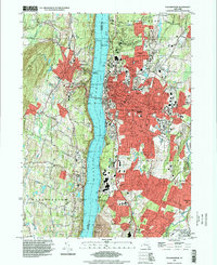
1995 Map of Poughkeepsie
USGS Topo · Published 1998About this map
The Hudson River serves as the central artery of this mid-1990s landscape, dividing the dense urban development of Poughkeepsie from the fruit-growing ridges of Lloyd and Marlborough. On the eastern bank, the city is characterized by major institutional campuses, including Vassar College, Marist College, and the extensive grounds of the Hudson River State Hospital. These large parcels of land, along with St Peters Cemetery and the Rural Cemetery, create significant greenbelts amidst the residential expansion of Arlington and Fairview. Transport connections are anchored by the Mid-Hudson Bridge and the rail lines of Conrail and Penn Central, which follow the river's edge. To the south, the industrial and recreational footprint of the IBM Country Club and Wappingers Falls Airport marks the transition toward the suburban reach of Red Oaks Mill.
Find a feature on this map
66 named features on this map. Tap any name to fly to it.
Don’t see what you’re looking for? This feature index may not catch every label — zoom into the map to look around manually.
Map Details
Editions of this 1995 Poughkeepsie Map
This is the sole edition of this map. No revisions or reprints were ever made.
Other maps of this area

1893 · Poughkeepsie
USGS Topo · 1:62,500

1894 · Poughkeepsie
USGS Topo · 1:62,500

1898 · Rhinebeck
USGS Topo · 1:62,500

1901 · Rosendale
USGS Topo · 1:62,500

1903 · Poughkeepsie
USGS Topo · 1:62,500

1903 · Newburg
USGS Topo · 1:62,500

1903 · Rosendale
USGS Topo · 1:62,500

1934 · Rhinebeck
USGS Topo · 1:48,000

1936 · Poughkeepsie
USGS Topo · 1:48,000

1939 · Rhinebeck
USGS Topo · 1:62,500