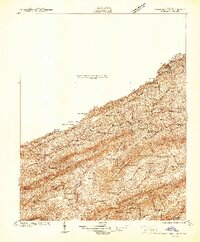
1941 Map of Pounding Mill
USGS Topo · Published 1941About this map
Tazewell and its northern counterpart North Tazewell anchor this landscape during the early 1940s, a period defined by the busy Norfolk and Western Ry line following the Clinch River. The map reveals a corridor of small rail-side settlements and industrial markers such as Maxwell Sta, Pounding Mill, and the local Fair Grounds. The topography is dominated by a series of long, parallel ridges including Deskin Mountain and Paint Lick Mountain, which compartmentalize the region into distinct agricultural valleys.
Find a feature on this map
92 named features on this map. Tap any name to fly to it.
Don’t see what you’re looking for? This feature index may not catch every label — zoom into the map to look around manually.
Map Details
Editions of this 1941 Pounding Mill Map
This is the sole edition of this map. No revisions or reprints were ever made.
Other maps of this area

1887 · Pocahontas
USGS Topo · 1:125,000

1889 · Wytheville
USGS Topo · 1:125,000

1891 · Tazewell
USGS Topo · 1:125,000

1891 · Pocahontas
USGS Topo · 1:125,000

1891 · Abingdon
USGS Topo · 1:125,000

1892 · Wytheville
USGS Topo · 1:125,000

1894 · Pocahontas
USGS Topo · 1:125,000

1894 · Abingdon
USGS Topo · 1:125,000

1895 · Tazewell
USGS Topo · 1:125,000

1895 · Pocahontas
USGS Topo · 1:125,000