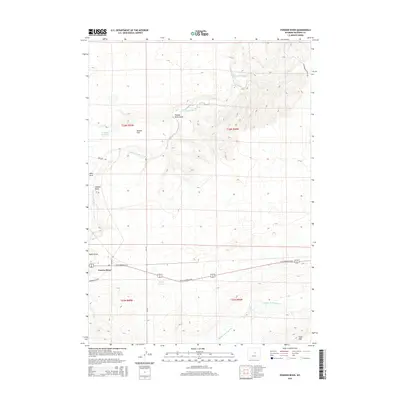
2015 Map of Powder River
USGS Topo · Published 2015About this map
Powder River serves as the primary hub of this high-plains landscape, situated where the S Fork Powder River and numerous drainage draws shape the basin. The settlement is anchored by a transport corridor including W US Highway 20-26 and Powder River Rd, reflecting the area's importance as a crossroads in central Wyoming. The terrain is characterized by broad topographic features such as Brewer Flat and deep erosional cuts like Powder River Draw and Hohnen Draw. Water management in this arid environment is evident through several catchments, notably Burke Reservoir and Brewer Reservoir. To the south, the elevation rises toward the base of Pine Mtn, while the Cottonwood Stock Trl in the northeast suggests a legacy of livestock movement through these range lands. The drainage of Middle Fork Casper Cr further defines the southern reaches of the quadrangle.
Find a feature on this map
20 named features on this map. Tap any name to fly to it.
Don’t see what you’re looking for? This feature index may not catch every label — zoom into the map to look around manually.
Map Details
Editions of this 2015 Powder River Map
This is the sole edition of this map. No revisions or reprints were ever made.
Other maps of this area

1951 · Square Top Butte
USGS Topo · 1:24,000

1951 · Reid Canyon
USGS Topo · 1:24,000

1955 · Arminto
USGS Topo · 1:250,000

1955 · Casper
USGS Topo · 1:250,000

1958 · Casper
USGS Topo · 1:250,000

1958 · Arminto
USGS Topo · 1:250,000

1959 · Gaylord Reservoir
USGS Topo · 1:24,000

1962 · Arminto
USGS Topo · 1:250,000

1962 · Casper
USGS Topo · 1:250,000
1968 · Notches Dome
USGS Topo · 1:24,000