
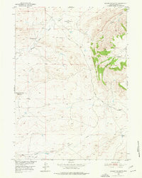
1951 Map of Square Top Butte
USGS Topo · Published 1953About this map
McFarland Ranch and the early cold-war era USAF Bombing Range No 4 (Inactive) anchor this mid-century survey of the Natrona County landscape. The terrain is defined by the prominent Pine Mountain and the distinct landmark of Square Top Butte, with drainage systems including the Middle Fork Casper Creek and South Fork Casper Creek. Evidence of Wyoming's growing energy infrastructure is visible through an Oil Well, Oil Tanks, and a long-distance Pipe Line traversing the southern portion of the sheet. The network of unimproved roads, such as the Powder River Road along the Powder River, illustrates the logistical patterns of ranching and industry in the high plains shortly after the second world war. Topographic detail also reveals a Spillway and the winding reaches of Smith Canyon to the northeast.
Find a feature on this map
15 named features on this map. Tap any name to fly to it.
Don’t see what you’re looking for? This feature index may not catch every label — zoom into the map to look around manually.
Map Details
Editions of this 1951 Square Top Butte Map
2 editions found
Other maps of this area

1951 · Pine Mountain SW
USGS Topo · 1:24,000

1951 · Poison Spider
USGS Topo · 1:24,000

1951 · Reid Canyon
USGS Topo · 1:24,000

1955 · Arminto
USGS Topo · 1:250,000

1955 · Casper
USGS Topo · 1:250,000

1958 · Casper
USGS Topo · 1:250,000

1958 · Arminto
USGS Topo · 1:250,000

1959 · Gaylord Reservoir
USGS Topo · 1:24,000

1959 · Eightmile Draw
USGS Topo · 1:24,000

1962 · Arminto
USGS Topo · 1:250,000