
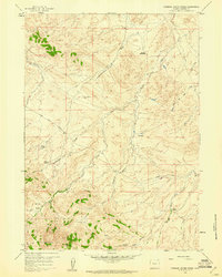
1959 Map of Eightmile Draw
USGS Topo · Published 1960About this map
Eightmile Draw and its network of dry creek beds define this portion of the Wyoming high plains in the mid-1950s. The landscape is dominated by a complex drainage system that includes the South Fork Casper Creek and Poison Spider Creek. In an area where water and reliable transit are central to survival, the map documents a single point of human residence at Garson Ranch, which was already noted as abandoned by the time of the 1959 field check. Evidence of regional infrastructure appears in the eastern reaches, where a telephone road parallels the creek, reflecting the sparse but essential connectivity required in this Natrona County terrain. The survey captures the intricate topography of numerous drainages such as Coyote Creek, Soap Creek, and Cabin Creek, which cut through the ridges of the high desert plateau.
Find a feature on this map
8 named features on this map. Tap any name to fly to it.
Don’t see what you’re looking for? This feature index may not catch every label — zoom into the map to look around manually.
Map Details
Editions of this 1959 Eightmile Draw Map
This is the sole edition of this map. No revisions or reprints were ever made.
Other maps of this area

1951 · Pine Mountain SW
USGS Topo · 1:24,000

1951 · Mc Cleary Reservoir
USGS Topo · 1:24,000

1951 · Square Top Butte
USGS Topo · 1:24,000

1955 · Casper
USGS Topo · 1:250,000

1958 · Casper
USGS Topo · 1:250,000

1959 · Gaylord Reservoir
USGS Topo · 1:24,000

1959 · Broad Mesa
USGS Topo · 1:24,000

1959 · Horse Creek Springs
USGS Topo · 1:24,000
1959 · Stinking Water Creek
USGS Topo · 1:24,000

1959 · Saddle Rock
USGS Topo · 1:24,000