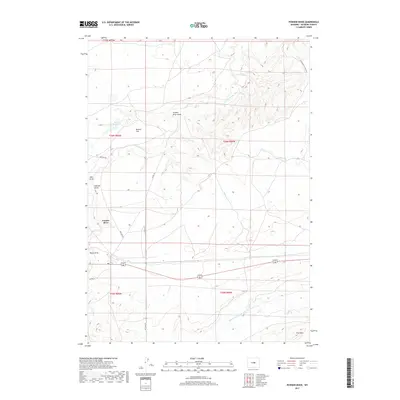
2017 Map of Powder River
USGS Topo · Published 2017About this map
Powder River serves as the focal point of this Natrona County landscape, situated where the high plains meet significant topographic shifts. The presence of the Cottonwood Stock Trl and Oil Camp Rd indicates a working landscape defined by traditional ranching routes and energy development. The drainage network is complex, characterized by numerous erosional features such as Powder River Draw, Ohio Draw, and Hohnen Draw, which channel seasonal runoff toward the S Fork Powder River. To the south, the terrain rises toward Pine Mtn, while Brewer Reservoir and Brewer Flat provide critical water management points in an otherwise arid environment. This 2017 survey by the U.S. Geological Survey captures the modern infrastructure of the region, including Notches Rd, overlaid on a classic Wyoming high-desert basin.
Find a feature on this map
20 named features on this map. Tap any name to fly to it.
Don’t see what you’re looking for? This feature index may not catch every label — zoom into the map to look around manually.
Map Details
Editions of this 2017 Powder River Map
This is the sole edition of this map. No revisions or reprints were ever made.
Other maps of this area

1951 · Square Top Butte
USGS Topo · 1:24,000

1951 · Reid Canyon
USGS Topo · 1:24,000

1955 · Arminto
USGS Topo · 1:250,000

1955 · Casper
USGS Topo · 1:250,000

1958 · Casper
USGS Topo · 1:250,000

1958 · Arminto
USGS Topo · 1:250,000

1959 · Gaylord Reservoir
USGS Topo · 1:24,000

1962 · Arminto
USGS Topo · 1:250,000

1962 · Casper
USGS Topo · 1:250,000
1968 · Notches Dome
USGS Topo · 1:24,000