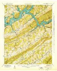
1942 Map of Powder Springs
USGS Topo · Published 1942About this map
Norris Reservoir dominates this landscape, having recently transformed the valley where the Clinch River and Straight Creek meet. This 1942 edition reveals the impact of the Tennessee Valley Authority on East Tennessee, showing the jagged fingers of the new shoreline reaching into Hogskin Valley and Little Valley. Amidst the ridges of Lone Mountain and Wallen Ridge, rural life persists at the community of Powder Springs and around family landmarks like the Butcher Cem and Braden Cem. The map documents a transition from old river-bottom living to a reservoir economy, evidenced by Cedar Grove Dock and the Walker Ford Lookout Tower. Genealogists will find a wealth of local landmarks, from Navehill Sch to Pennington Chapel, many located along the Southern Railway or tucked into gaps like Acuff Gap.
Find a feature on this map
78 named features on this map. Tap any name to fly to it.
Don’t see what you’re looking for? This feature index may not catch every label — zoom into the map to look around manually.
Map Details
Editions of this 1942 Powder Springs Map
This is the sole edition of this map. No revisions or reprints were ever made.
Other maps of this area

1897 · Maynardville
USGS Topo · 1:125,000

1900 · Maynardville
USGS Topo · 1:125,000

1935 · Luttrell
USGS Topo · 1:24,000

1935 · Straw Plains
USGS Topo · 1:48,000

1935 · Graveston
USGS Topo · 1:24,000

1935 · Joppa
USGS Topo · 1:24,000

1936 · Gorryton
USGS Topo · 1:48,000

1936 · Powder Springs
USGS Topo · 1:24,000

1936 · Ausmus
USGS Topo · 1:24,000
1936 · Clouds
USGS Topo · 1:24,000