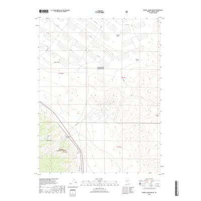
2018 Map of Powell Mountain NE
USGS Topo · Published 2018About this map
The Hawthorne Army Depot occupies a significant portion of this high desert landscape, defined by a rigid grid of specialized roads like 2nd Ave S and East Rd. This military footprint transitions abruptly into the dramatic terrain of the Wassuk Range and Garfield Hills, where the land is carved by deep seasonal drainages such as Bromide Canyon and Pamlico Canyon. To the southwest, the boundary of the Toiyabe National Forest encompasses the upper reaches of Cottonwood Cr, illustrating the jurisdictional complexity of Nevada's public lands. The presence of routes named N Johnston and Long Johnston suggests a legacy of local land use or ranching family history predating or coinciding with the military and forestry designations. This 2018 survey provides a clear look at how industrial-military infrastructure and natural canyons intersect in Mineral County.
Find a feature on this map
26 named features on this map. Tap any name to fly to it.
Don’t see what you’re looking for? This feature index may not catch every label — zoom into the map to look around manually.
Map Details
Editions of this 2018 Powell Mountain NE Map
This is the sole edition of this map. No revisions or reprints were ever made.
Other maps of this area

1909 · Hawthorne
USGS Topo · 1:250,000

1911 · Hawthorne
USGS Topo · 1:250,000

1915 · Hawthorne
USGS Topo · 1:250,000

1948 · Walker Lake
USGS Topo · 1:250,000

1955 · Powell Mtn
USGS Topo · 1:62,500

1955 · Hawthorne
USGS Topo · 1:62,500

1957 · Walker Lake
USGS Topo · 1:250,000

1962 · Walker Lake
USGS Topo · 1:250,000

1964 · Walker Lake
USGS Topo · 1:250,000

1967 · Pamlico
USGS Topo · 1:24,000