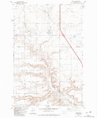
1983 Map of Power
USGS Topo · Published 1983About this map
Power stands as the primary settlement on this western Montana landscape, situated where the Burlington Northern railroad tracks parallel the Muddy Creek valley. The map reveals a highly structured agricultural environment defined by a series of geographic terraces known as First Bench, Second Bench, and Third Bench. These landforms are gridded by an orderly system of local roads, from First Road North through Seventh Road North, reflecting a deliberate division of the plains for farming and ranching.
Find a feature on this map
27 named features on this map. Tap any name to fly to it.
Don’t see what you’re looking for? This feature index may not catch every label — zoom into the map to look around manually.
Map Details
Editions of this 1983 Power Map
This is the sole edition of this map. No revisions or reprints were ever made.
Other maps of this area

1886 · Great Falls
USGS Topo · 1:250,000

1949 · Vaughn
USGS Topo · 1:62,500

1950 · Fairfield
USGS Topo · 1:62,500

1950 · Dutton
USGS Topo · 1:62,500

1950 · Collins
USGS Topo · 1:62,500

1952 · Vaughn
USGS Topo · 1:62,500

1954 · Great Falls
USGS Topo · 1:250,000

1957 · Great Falls
USGS Topo · 1:250,000

1976 · Great Falls North
USGS Topo · 1:100,000
1983 · Vaughn NE
USGS Topo · 1:24,000