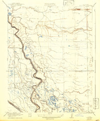
1922 Map of Pozo Farm
USGS Topo · Published 1942About this map
Pozo Farm sits at the heart of this agricultural landscape in the San Joaquin Valley, where the boundary between Madera Co and Fresno Co follows the winding course of the San Joaquin River. This 1920s-era survey reveals a complex network of water management essential for the region's development, featuring the San Joaquin and Kings River Canal and natural drainage systems like Berenda Slough and Lone Willow Slough.
Find a feature on this map
11 named features on this map. Tap any name to fly to it.
Don’t see what you’re looking for? This feature index may not catch every label — zoom into the map to look around manually.
Map Details
Editions of this 1922 Pozo Farm Map
2 editions found
Other maps of this area

1913 · Panoche
USGS Topo · 1:125,000

1916 · Santa Rita Bridge
USGS Topo · 1:24,000

1918 · Bliss Ranch
USGS Topo · 1:31,680

1918 · Chowchilla
USGS Topo · 1:31,680

1920 · Santa Rita Bridge
USGS Topo · 1:31,680

1921 · Mendota
USGS Topo · 1:31,680

1922 · Oxalis
USGS Topo · 1:31,680

1922 · Santa Rita Bridge
USGS Topo · 1:31,680

1922 · Pozo Farm
USGS Topo · 1:31,680

1922 · Kentucky Well
USGS Topo · 1:31,680