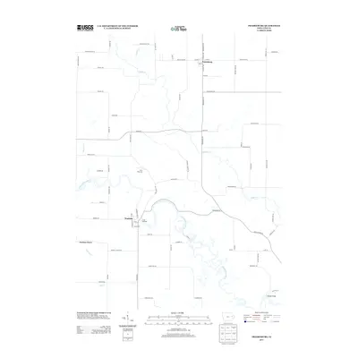
2013 Map of Prairieburg
USGS Topo · Published 2013About this map
Prairieburg anchors this rural Linn County landscape, where the agricultural grid is deeply carved by the meandering Wapsipinicon River and its numerous tributaries. Small crossroads and historically significant hamlets like Waubeek, Jordans Grove, and Necot suggest an earlier era of decentralized local trade and community centers. The winding river valley provides a distinct contrast to the straight section lines of the surrounding uplands, sheltering recreation sites such as Camp Wakomda and Camp Waubeek. Numerous watercourses, including Buffalo Cr, Boulder Cr, and Big Cr, create a complex drainage network that has dictated the placement of local roads like Waubeek Rd and Jordans Grove Rd. This 2013 survey reflects a quiet Iowa countryside where the names of early settlers remain etched into the landscape through landmarks and named creeks like Heatons Cr and E Indian Cr.
Find a feature on this map
76 named features on this map. Tap any name to fly to it.
Don’t see what you’re looking for? This feature index may not catch every label — zoom into the map to look around manually.
Map Details
Editions of this 2013 Prairieburg Map
This is the sole edition of this map. No revisions or reprints were ever made.
Other maps of this area

1888 · Marion
USGS Topo · 1:62,500

1889 · Marion
USGS Topo · 1:62,500

1890 · Anamosa
USGS Topo · 1:62,500

1900 · Anamosa
USGS Topo · 1:125,000

1903 · Winthrop
USGS Topo · 1:125,000

1959 · Dubuque
USGS Topo · 1:250,000

1961 · Dubuque
USGS Topo · 1:250,000

1962 · Dubuque
USGS Topo · 1:250,000
1968 · Central City
USGS Topo · 1:24,000
1968 · Marion
USGS Topo · 1:24,000