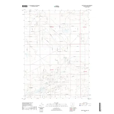
2017 Map of Pratts Soda Lakes
USGS Topo · Published 2017About this map
Evansville anchors the southwest corner of this high-plains landscape, where the Casper area transitions into a grid of residential and ranch developments. The terrain is defined by its distinct alkali water bodies, most notably the Pratts Soda Lakes and the isolated Suicide Soda Lake. These basins sit amidst a complex network of modern road names that evoke Wyoming's frontier heritage, including Pony Express Dr, Wagon Train Way, and Bridger Trl. The survey captures a moment of suburban expansion into the high desert, evidenced by the proliferation of named streets like BB Brooks Blvd and Cowboy Way that carve through the open sections of t35n r78w and t34n r78w. This 2017 study illustrates the intersection of traditional land survey divisions and contemporary residential planning in Natrona County.
Find a feature on this map
74 named features on this map. Tap any name to fly to it.
Don’t see what you’re looking for? This feature index may not catch every label — zoom into the map to look around manually.
Map Details
Editions of this 2017 Pratts Soda Lakes Map
This is the sole edition of this map. No revisions or reprints were ever made.
Other maps of this area

1949 · Brookhurst
USGS Topo · 1:24,000

1949 · Campbell Hill
USGS Topo · 1:24,000

1949 · Pratts Soda Lakes
USGS Topo · 1:24,000

1950 · Campbell Hill
USGS Topo · 1:24,000

1950 · Lockett
USGS Topo · 1:24,000

1950 · Brookhurst
USGS Topo · 1:24,000

1950 · Pratts Soda Lakes
USGS Topo · 1:24,000

1951 · The Reefs
USGS Topo · 1:24,000

1951 · Casper
USGS Topo · 1:24,000

1955 · Arminto
USGS Topo · 1:250,000