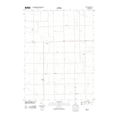
2010 Map of Preble
USGS Topo · Published 2010About this map
Preble and Tocsin anchor this northern Indiana landscape, where a sophisticated network of drainage infrastructure allows for intensive agriculture. The map detail reflects a region defined by its water management, including the Werling Joint Ditch, Pigeon Number Two Ditch, and Gerber Joint Ditch, which channel water toward natural courses like Eightmile Creek. For genealogists and local historians, the sheet identifies several distinct community burial sites such as Prairie View Cemetery and Salem Cemetery, alongside small crossroads settlements like Magley, Peterson, and Honduras. The rural character is further punctuated by The Lazy K Airport, situated north of Craigville. This 2010 survey provides a clear view of the rectilinear road grid and the myriad of named ditches that have historically transformed these wetlands into productive farmland.
Find a feature on this map
40 named features on this map. Tap any name to fly to it.
Don’t see what you’re looking for? This feature index may not catch every label — zoom into the map to look around manually.
Map Details
Editions of this 2010 Preble Map
This is the sole edition of this map. No revisions or reprints were ever made.
Other maps of this area

1911 · Berne
USGS Topo · 1:48,000

1953 · Muncie
USGS Topo · 1:250,000

1956 · Muncie
USGS Topo · 1:250,000

1961 · Hoagland
USGS Topo · 1:24,000

1962 · Poe
USGS Topo · 1:24,000

1962 · Uniondale
USGS Topo · 1:24,000

1962 · Ossian
USGS Topo · 1:24,000

1962 · Preble
USGS Topo · 1:24,000

1962 · Berne
USGS Topo · 1:24,000
1962 · Decatur
USGS Topo · 1:24,000