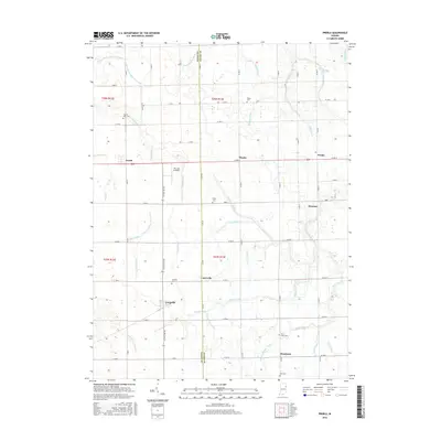
2016 Map of Preble
USGS Topo · Published 2016About this map
Agricultural patterns and a dense network of drainage engineering define this portion of the Indiana plains along the Wells and Adams county line. Small settlements like Preble, Tocsin, and Magley are linked by straight-line roads and the north-south corridor of N State Rd 301. The landscape is intricately managed by numerous named ditches such as Eightmile Number Two Ditch, Lambert Ditch, and Werling-Myers Ditch, illustrating the systematic conversion of wetlands into productive farmland. Genealogists will find several rural burial grounds preserved throughout the townships, including Prairie View Cem, Shady Cem, and Saint Lukes Cem. The presence of The Lazy K Airport near Eightmile Creek provides a notable landmark amidst the sprawling fields, while the cluster of small communities like Peterson, Curryville, and Honduras reflects the enduring nature of local crossroads hamlets in this part of the state.
Find a feature on this map
45 named features on this map. Tap any name to fly to it.
Don’t see what you’re looking for? This feature index may not catch every label — zoom into the map to look around manually.
Map Details
Editions of this 2016 Preble Map
This is the sole edition of this map. No revisions or reprints were ever made.
Other maps of this area

1911 · Berne
USGS Topo · 1:48,000

1953 · Muncie
USGS Topo · 1:250,000

1956 · Muncie
USGS Topo · 1:250,000

1961 · Hoagland
USGS Topo · 1:24,000

1962 · Poe
USGS Topo · 1:24,000

1962 · Uniondale
USGS Topo · 1:24,000

1962 · Ossian
USGS Topo · 1:24,000

1962 · Preble
USGS Topo · 1:24,000

1962 · Berne
USGS Topo · 1:24,000
1962 · Decatur
USGS Topo · 1:24,000