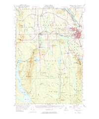
1953 Map of Presque Isle
USGS Topo · Published 1984About this map
Presque Isle Air Force Base and the Aroostook State Teachers College define the mid-century landscape of this northern Maine hub. The region is a mix of military presence, agricultural research at the State Experimental Farm, and local industry connected by the Bangor and Aroostook railroad. To the west and south, the terrain rises toward Squa Pan Mountain and Haystack Mtn, while the Aroostook River and Presque Isle Stream anchor the drainage system. Rural life is evidenced by scattered schoolhouses like Hillside Sch and crossroads such as Deadmans Cor. The presence of the Squa Pan Fire Tower overlooking Squa Pan Lake reflects the vital role of forest management and fire lookout systems in the 1950s Maine wilderness during a time of significant post-war development in Aroostook County.
Find a feature on this map
86 named features on this map. Tap any name to fly to it.
Don’t see what you’re looking for? This feature index may not catch every label — zoom into the map to look around manually.
Map Details
Editions of this 1953 Presque Isle Map
5 editions found

Other maps of this area

1929 · Portage
USGS Topo · 1:62,500

1929 · Caribou
USGS Topo · 1:48,000

1930 · Fort Fairfield
USGS Topo · 1:48,000

1931 · Ashland
USGS Topo · 1:48,000

1931 · Portage
USGS Topo · 1:62,500

1932 · Caribou
USGS Topo · 1:62,500

1933 · Fort Fairfield
USGS Topo · 1:62,500

1934 · Bridgewater
USGS Topo · 1:48,000

1934 · Ashland
USGS Topo · 1:62,500

1935 · Howe Brook
USGS Topo · 1:48,000