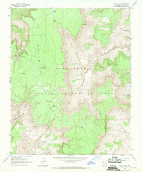
1967 Map of Price Point
USGS Topo · Published 1970About this map
Shivwits Plateau dominates this high-desert landscape in northern Arizona, as documented during the late 1960s. The terrain is defined by a series of deep drainage systems, including Two Hundred and Ninemile Canyon and Separation Canyon, which cut through the high elevations near Blue Mtn. Part of the Lake Mead National Recreation Area, the region lacks permanent settlements, instead featuring a network of livestock or wildlife watering points such as Shanley Tanks, Deer Flat Tank, and Kelly Tanks. These features, alongside isolated geographical markers like Price Point and Dinner Pocket, reflect a landscape managed for conservation and limited rangeland use. A singular Jeep Trail provides the only mapped evidence of modern traversal through these remote canyons and plateaus.
Find a feature on this map
18 named features on this map. Tap any name to fly to it.
Don’t see what you’re looking for? This feature index may not catch every label — zoom into the map to look around manually.
Map Details
Editions of this 1967 Price Point Map
This is the sole edition of this map. No revisions or reprints were ever made.
Other maps of this area

1886 · Diamond Creek
USGS Topo · 1:250,000

1886 · Mt. Trumbull
USGS Topo · 1:250,000

1892 · Diamond Creek
USGS Topo · 1:250,000

1892 · Mt. Trumbull
USGS Topo · 1:250,000

1948 · Williams
USGS Topo · 1:250,000

1953 · Grand Canyon
USGS Topo · 1:250,000

1954 · Williams
USGS Topo · 1:250,000

1956 · Williams
USGS Topo · 1:250,000

1957 · Grand Canyon
USGS Topo · 1:250,000

1958 · Grand Canyon
USGS Topo · 1:250,000