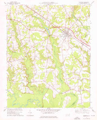
1974 Map of Princeton
USGS Topo · Published 1976About this map
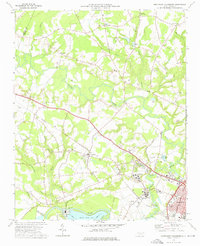
Princeton serves as the primary hub in this eastern North Carolina landscape, where the Southern railroad line cuts a straight path through the lowlands of Johnston Co and Wayne Co. The terrain is defined by an intricate network of wetlands and watercourses, including Quaker Swamp, Bawdy Swamp, and Raccoon Swamp, which feed into Moccasin Creek and the meandering Neuse River to the south. This 1974 survey captures a rural social geography centered on small community landmarks and family-named points of interest.
Find a feature on this map
32 named features on this map. Tap any name to fly to it.
Don’t see what you’re looking for? This feature index may not catch every label — zoom into the map to look around manually.
Map Details
Editions of this 1974 Princeton Map
This is the sole edition of this map. No revisions or reprints were ever made.
Other maps of this area

1902 · Kenly
USGS Topo · 1:62,500

1903 · Kenly
USGS Topo · 1:62,500

1906 · Four Oaks
USGS Topo · 1:48,000

1908 · Four Oaks
USGS Topo · 1:62,500

1953 · Raleigh
USGS Topo · 1:250,000

1954 · Raleigh
USGS Topo · 1:250,000
1964 · Selma
USGS Topo · 1:62,500
1964 · Selma
USGS Topo · 1:24,000
1974 · Grantham
USGS Topo · 1:24,000
1974 · Northwest Goldsboro
USGS Topo · 1:24,000