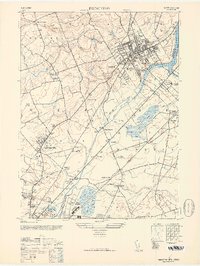
1946 Map of Princeton
USGS Topo · Published 1952About this map
Princeton University dominates the northeastern landscape of this mid-century survey, surrounded by the distinctive architecture of the Theological Seminary and Princeton High School. The academic core is bordered by Lake Carnegie and the Millstone River, while to the south, the industrial and commercial influence of the Pennsylvania railroad corridor is evident at Princeton Junction and Lawrence Sta. The terrain transitions from the heights of Rocky Hill and Mount Rose in the north to the low-lying marshes and creeks around Hamilton.
Find a feature on this map
67 named features on this map. Tap any name to fly to it.
Don’t see what you’re looking for? This feature index may not catch every label — zoom into the map to look around manually.
Map Details
Editions of this 1946 Princeton Map
This is the sole edition of this map. No revisions or reprints were ever made.
Other maps of this area

1888 · Bordentown
USGS Topo · 1:62,500

1888 · Princeton
USGS Topo · 1:62,500

1890 · Lambertville
USGS Topo · 1:62,500

1890 · Burlington
USGS Topo · 1:62,500

1891 · Lambertville
USGS Topo · 1:62,500

1893 · Bordentown
USGS Topo · 1:62,500

1893 · Burlington
USGS Topo · 1:62,500

1894 · Princeton
USGS Topo · 1:62,500

1894 · Lambertville
USGS Topo · 1:62,500

1904 · Burlington
USGS Topo · 1:62,500