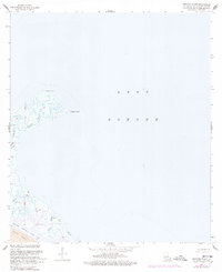
1968 Map of Proctor Point
USGS Topo · Published 1978About this map
Proctor Point reaches into the expansive waters of Lake Borgne in this late-1960s coastal survey of St. Bernard Parish. The landscape is defined by an intricate network of tidal channels including Bayou Flagpole, Camp Bayou, and Grand Bayou. To the south, the industrial footprint of the mid-20th century is evident where the Mississippi River-Gulf Outlet Canal cuts through the marshland, flanked by a designated Spoil Area. Local-history researchers can observe the hydrographic shifts between the original 1952 planimetry and the 1976 photorevisions, particularly around Flat Bayou and Stump Bayou. Small navigation markers and a Drill Hole highlight the intersection of coastal shipping and resource exploration in this marshy environment.
Find a feature on this map
17 named features on this map. Tap any name to fly to it.
Don’t see what you’re looking for? This feature index may not catch every label — zoom into the map to look around manually.
Map Details
Editions of this 1968 Proctor Point Map
2 editions found
Other maps of this area

1892 · Chef Menteur
USGS Topo · 1:62,500

1892 · St. Bernard
USGS Topo · 1:62,500

1893 · Rigolets
USGS Topo · 1:62,500

1893 · Shell Beach
USGS Topo · 1:62,500

1935 · Delacroix
USGS Topo · 1:31,680

1936 · Chef Menteur
USGS Topo · 1:62,500

1936 · Rigolets
USGS Topo · 1:62,500

1937 · Chef Menteur
USGS Topo · 1:31,680

1939 · Shell Beach
USGS Topo · 1:62,500
1941 · Delacroix
USGS Topo · 1:31,680