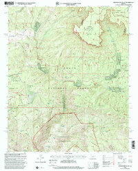
1998 Map of Promontory Butte
USGS Topo · Published 2001About this map
Mogollon Rim forms a massive geological divide across this Gila County landscape, marking the transition from the high Colorado Plateau to the deep canyons below. Along the base of this escarpment, the drainage of Tonto Creek and its tributaries, such as Horton Creek and Dick Williams Creek, supported the development of seasonal communities and recreational retreats. The map highlights the layout of Kohls Ranch and several dispersed residential areas including Mountain Meadow and Christopher Creek. This 1990s revision reflects a landscape managed for both timber and recreation, where the Highline Trail traverses the slope below Promontory Butte. The transition from the Sitgreaves National Forest atop the rim to the Tonto National Forest and Hellsgate Wilderness in the southern sections illustrates the complex topographical and jurisdictional layers of the Arizona backcountry.
Find a feature on this map
65 named features on this map. Tap any name to fly to it.
Don’t see what you’re looking for? This feature index may not catch every label — zoom into the map to look around manually.
Map Details
Editions of this 1998 Promontory Butte Map
This is the sole edition of this map. No revisions or reprints were ever made.
Other maps of this area

1886 · Holbrook
USGS Topo · 1:250,000

1887 · Verde
USGS Topo · 1:250,000

1892 · Verde
USGS Topo · 1:250,000

1893 · Holbrook
USGS Topo · 1:250,000

1934 · Promontory Butte
USGS Topo · 1:62,500

1937 · Diamond Butte
USGS Topo · 1:48,000

1939 · Promontory Butte
USGS Topo · 1:62,500

1943 · Diamond Butte
USGS Topo · 1:62,500

1952 · Promontory Butte
USGS Topo · 1:62,500

1954 · Holbrook
USGS Topo · 1:250,000
Featured Places
- Thompson Draw Summer Homes Unit #1, AZ
- Tonto Estate, AZ
- Hunter Creek, AZ
- Bear Flat, AZ
- Christopher Creek, AZ